Tag Archives: Orkney

What Rubber Ducks Tell Us about the World

Before we dive into today’s topic, let’s talk about two of my favourite words: Flotsam and Jetsam. I just love the way they sound! The way I understand them, the difference between the two is intention: Flotsam are things unintentionally donated to the sea – things washed overboard from a ship, or things blown off land by a storm. Jetsam is rather something intentionally jettisoned – if a ship needs to lighten its load to avoid sinking, for instance; in the case of the great garbage patches, it is a mixture of both: Without proper disposal systems in place, such as municipal garbage disposal, or education in ecological footprints, social debris is simply tossed and forgotten. But it ends up somewhere, often finding its way to the ocean through rivers and streams. And this leads us to the topic of ocean currents.

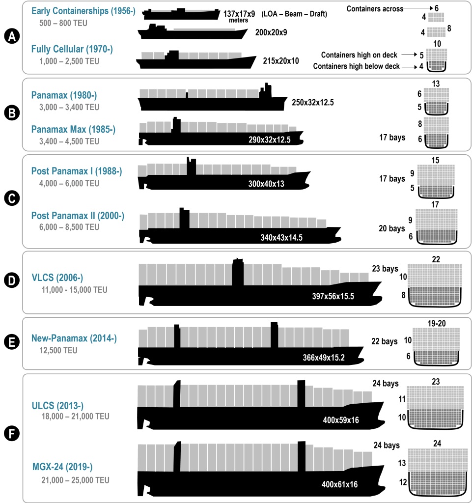
Today’s topic is a fascinating dive into a world of global trade; research has shown that around 90% of international trade is carried by shipping containers, and the World Bank statistics show that in 2019, nearly 800 million were shipped annually; given the increase over the past few years in online shopping, I can imagine that figure is by now significantly higher. The unit used for measuring how much a ship can carry is TEU (Twenty-foot Equivalent Unit); the chart below shows the adaptation of ship sizes over the years, driven by global trade:

Now, imagine a shipping container stacked at the top of a pile that’s the height of the actual ship; add to that ocean swells and waves. I’ve been on ships in the Atlantic facing waves so high, I could count fish through my window. I’ve been on ships in the “Sailor’s Nightmare” – the Pentland Firth passage between Scotland and the Orkney Islands – which is characterised by rough bathymetry (the underwater equivalent to topography) and extremely high currents (which also ricochet and collide off of the coasts of the islands and Scottish cliffs), tossing anything on the surface like a leaf in the wind. The World Shipping Council estimates that, over the past 16 years, an average of 1,500 containers have been lost at sea annually. Every year, the contents of those containers are carried along until the container is breached by either corrosion or impact. Then the contents are carried by ocean currents; where they finally make landfall depends on where they entered the ocean. If you were marooned on an island and tossed out an SOS in a bottle, it could make landfall anywhere between two and one hundred years – or never, if it’s caught in a gyre (more on that later). A message in a bottle was found on a beach in Norway that had been sent off 101 years earlier.

So what does that have to do with rubber ducks? In 1992, a shipping container with a consignment of what has been dubbed Friendly Floatees – 28,800 yellow rubber ducks, red beavers, blue turtles and green frogs – was washed overboard (along with 11 other containers) into the Atlantic. Because they are designed to float on water, they have survived at sea for an amazingly long time. Seattle oceanographers Curtis Ebbesmeyer and James Ingraham, who were working on an ocean current model, OSCUR (Ocean Surface Currents Simulation), began to track their progress; and those wee toys went on all kinds of adventures: Ten months after they broke free, some began showing up along the Alaskan coast; some showed up in Hawaii; some went to see the site of the Titanic sinking before getting frozen into ice, eventually emerging again and travelling to the US eastern coast, Britain and Ireland, making landfall around 2007. The researchers contacted coastal regions, asking beachcombers to report their finds; they recorded findings and began to accurately predict where landfall would occur. Over the years, the ducks and beavers had faded to white, but the blues and greens had retained their colours.

Flotsam and Jetsam have played key roles in helping researchers understand not only how ocean currents travel, but also how the areas known as garbage patches, oceanic gyres, are formed and retained by the swirl of ocean currents. Currently, five patches are known; many of the rubber ducks are likely caught in such currents, so we may hear about more white ducks finding their way to beaches in the coming years.

So the next time you see a rubber duck, think of all the adventures its siblings have been on!

If you’d like to see for yourself how ocean currents work, click here for an interactive map; just click on any area of the map to see how and where the currents carry debris from that point.
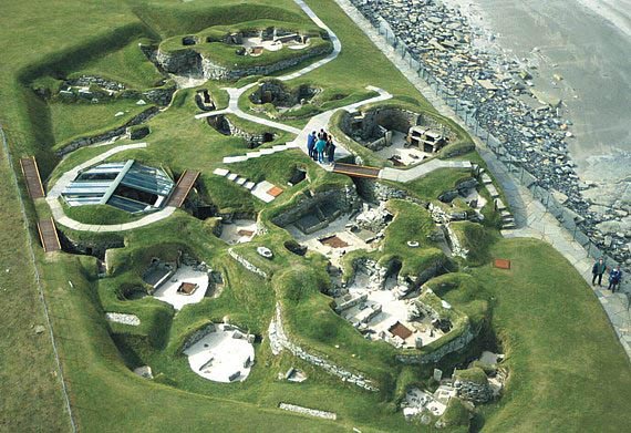
6 Comments

Filed under Articles, Etymology, History Undusted, Images, Nature, Research, Science & Technology, Snapshots in History

History Undusted: The Westray Dons

My past two articles have been about everyday phrases with maritime roots; not only is a language affected by sailors, but sometimes entire populations.

Around the British Isles, there have been countless shipwrecks. The waters can be treacherous, with islets and rocky outcrops just under the waves – splinters of divided continents worn down by the power of the sea until they become hidden snares. My husband and I were once on holiday on St Mary’s, Scilly Islands; with every tide, flotsam fragments of shipwrecks (nearly 1,000 known so far) from the 16th through the 19th centuries wash ashore, and I gathered a handful of beach pottery and glass, not knowing at the time that the worn but still decorated pieces could be centuries old. Buried beneath the sand, they’d retained their colourful glazing until washed ashore.

That’s the goods and plates aboard; but what of the people? Many sailors of past centuries couldn’t swim; if their ships foundered too far from shore, they sank to Davy Jones’s Locker. Those who were fortunate enough to make it ashore were not guaranteed a safe sojourn; if the island had scant supplies, it could get ugly – as it did for Spanish sailors on Fair Isle (more on that in a moment). But first, a brief background on the situation that led to the Spanish Armada being in British waters, and their shipwrecks:

The reasons the Armada moved to attack England are complex; let’s just say that Philip II, heir apparent to the Spanish throne, had married (in a political manoeuvre) Bloody Mary, the Catholic queen of England, who’d had her Protestant half-sister, Elizabeth, placed under house arrest to prevent any political ambitions from growing in the Protestant faction. When Mary died childless, Philip (King of Spain and Portugal, as well as of Ireland and England through marriage and until Mary’s death in 1558) returned to his own kingdom in Spain, and Queen Elizabeth I ascended to the throne of England. But being the daughter of King Henry VIII and his second wife, Anne Boleyn (whom he’d had executed when Elizabeth was two years old), Elizabeth was illegitimate in the eyes of many Catholics, as her parents’ marriage had been annulled two days before her mother’s execution. Ironically, confinement hadn’t taught Elizabeth any compassion; she had her Catholic cousin, Mary, Queen of Scots, imprisoned for nineteen years, and eventually executed in February of 1587. Mary had been Spain’s Catholic ally, and her death was the final straw for Philip II of Spain, as the religious tensions had been mounting between England and Spain. Philip prepared his Armada, sailing out of Lisbon in 1588.

If you look at a map of Europe, you will see that Spain is southwest of the British Isles; they had to sail through the Bay of Biscay, and then either west of England through the waters between England and Ireland, or east through the English Channel and French waters (and the French were usually at war with everyone) to reach the east coast of England.

Sir Francis Drake’s Revenge, with Armada ships in the background. Credit, Wikipedia

The battle ensued; the English ships had superior long-range cannon, with which they harried the Spanish fleet. Weather and prevailing winds interfered; battle lines were redrawn, only to be scuppered again. In August 1588, the Spanish fleet had been defeated by Sir Francis Drake’s command of the English ships, and the remnants of the fleet retreated into the North Sea. By early September, seventeen ships had been lost to storms. Many of the ships not sunk by the British navy or taken out by the sea were blown onto the rocky shores of Ireland and Scotland; of the 150 ships that set out from Lisbon, only 65 returned.

Replica of the 16th century Spanish Galeón Andalucía. Photo credit, Fundacion Nao Victoria. Click on the image to see details about the ship.

Three of the ships were separated in the storm from the rest of the fleet: The Barca de Amburgo foundered off of Fair Isle, but the crew was rescued by the El Gran Grifón and the Trinidad Valencera. With the extra crew aboard, the El Gran Grifón tried to anchor to make repairs but was wrecked on the rocks of Stroms Hellier, Fair Isles (a steep, rocky outcrop of land halfway between Shetland to the north and Orkney to the south). According to historian Sir Robert Sibbald (1641-1722), the crew was on the island for two months (~August-September 1588); though they paid for their supplies, tensions were high with locals as food stores were meagre and “Spanish money doesn’t fill hungry bellies”. The island itself has never supported more than 400 inhabitants (today’s population is 65); the Spanish shipwreck brought 300 to shore. 50 of the crew either starved to death or were killed when the locals turned on them: Any Spaniard found alone was tossed over a cliff; when that wasn’t efficient enough, the islanders deliberately collapsed a flagstone roof over the sleeping crew.

The survivors fled; some to Shetland, and some to Orkney. Enter that dusty bit of history, the Westray Dons.

Westray is the northernmost island of the Orkney archipelago, a group of 70 islands*, 16 of which are inhabited (*or more, depending on who you ask – skerries or uninhabited islets may or may not count). They not only welcomed the Spaniards but intermarried with them. The men remained on the island, and their descendants became known as the Westry Dons. Spanish heritage is still seen in the Orcadian population today, though the Dons are no longer a separate community; Orkney has a higher percentage of dark-haired, dark-eyed inhabitants than any other Scandinavian-heritage region. Orcadian oral tradition, according to the Sanday folklorist Walter Traill Dennison, says that the Dons were exceptional seamen, many of whose descendants went on to become sailors and sea captains. The Dons largely adopted Orcadian surnames, the most common (but not exclusively) being Petrie, Hewison, and Reid.

I hope you enjoyed this quick dive; if you’d like to read and hear a Scottish song about the Dons, just click here (warning: It’s in thick Scottish brogue!).

To see a timeline of the Spanish Armada battle, just click on the image below.

3 Comments

Filed under Articles, History, History Undusted, Links to External Articles, Military History, Snapshots in History

The History of Wedding Rings

Have you ever wondered when the tradition of wedding rings began?  How they developed in various cultures around the world?  To read a fascinating article on the topic, just click on the image below; the article includes images of amazing works of art worn on fingers centuries ago.  The image below, by the way, is of my own wedding ring; it’s a runic ring designed by Sheila Fleet in Orkney, Scotland, and it says, “dreams of everlasting love”.

Runic Wedding Ring


16 Comments

Filed under History, History Undusted, Links to External Articles, Research

History Undusted: Skara Brae, Orkney

Skara BraeSkara Brae is probably the single most famous Neolithic settlement uncovered in the world.  It gives us the most complete picture of everyday life in that period of time, and has quite a few surprises:  Indoor running water?  Dressers and beds?  Yep.  They had storage rooms, and even toys for the kids.  There are some objects that they can’t figure out, but that just makes it all the more tantalizing.

Originally much farther from the shoreline, over the centuries erosion has eaten away at the land; Skara Brae will itself eventually succumb to the pounding Atlantic waves.

I was there in 1989 for the first time, and again in 2002; the first time I was there, I was with a group of friends, and we were given a private tour by a friend’s uncle who worked there.  It was an amazing way to see this prehistoric site, tourist-free and (back then) largely untainted by tourism.  In 2002 it was a different matter altogether:  A tourist shop had sprung up, and we had to time our viewing between bus-loads of day-tourists from “doon sooth” (down south = Scotland).  Also on that second visit, the Atlantic winds were so strong that we were literally leaning into the wind at a 45° angle; if it had had a sudden lull, we would have been flung into the sunken dwellings; it was an adventure.

Skara Brae stone objectsIf you get a chance to go, do so; take at least a fortnight on Mainland Orkney.  It’s known as the Archaeologist’s treasure trove, and for good reason – just about any stone you turn over has some kind of historical significance, and there are many sites to take in:  Maeshowe, Ness of Brodgar and the Ring of Brodgar, and chambered cairns to name a few, and even more modern sites such as Churchill Barrier, and sunken World War 2 vessels (some portions are visible in low tide).

The stretch of water between Scotland and Orkney, the Pentland Firth, is known as “The Sailor’s Nightmare”; there are several currents that flow and mix into this bottleneck, not only making for treacherous sailing, but it can also make even the hardiest sailor lose his lunch.  Word to the wise:  When heading out of Thurso with the ferry to the Mainland (the largest island in the Orkney group), a) don’t eat yet (it usually leaves around lunch time, and believe me, you won’t keep it long…), and b) as soon as you get on the ferry, head to the dining room and get a window-side table; this is because they will not only fill up fast, but once you’re out of the relatively calm / wind-sheltered bay into the open strait, you’ll be glad for a ring-side view from a wind-sheltered, spray-sheltered spot; keeping your eye on the horizon helps the brain deal with the swells, and keeps seasickness at bay…

Originally posted on History Undusted,

2 Comments

Filed under Articles, History, History Undusted, Nuts & Bolts, Research, Science & Technology